Fichier:Jakarta Skyline Part 2.jpg


|
Copyright warning: A subject in this image is protected by copyright.
This image features an architectural or artistic work, photographed from a public space in Indonesia. There are no freedom of panorama exceptions of any kind under the Chapter VI (Copyright Limitations), Articles 43–51 of the Indonesian Copyright Act No. 28, 2014, which means that these architectural or artistic works cannot be photographed freely for anything other than non-commercial or personal uses. If a copyrighted architectural or artistic work is contained in this image and it is a substantial reproduction, this photo cannot be licensed under a free license, and will be deleted. Framing this image to focus on the copyrighted work is also a copyright violation. Before reusing this content, ensure that you have the right to do so. You are solely responsible for ensuring that you do not infringe someone else's copyrights. See our general disclaimer for more information. |

Description
| Description |
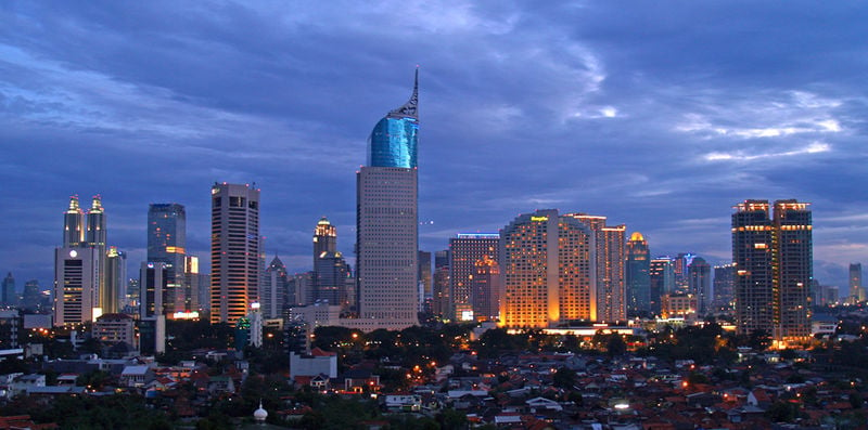
English: Lining up Jakarta's skyscrapers along the CBD with Wisma 46 as the centerpiece.
Wisma 46 is designed by Zeidler Partnership and has been well-known for being Indonesia's tallest building; and Jakarta's most distinguished skyscrapers with its unique shape resembling an elegant fountain pen. Singapore may have a "Durian" (The Esplanade); and Beijing has a "Bird's Nest" (Olympic Stadium) and "Trousers Pants" (CCTV Tower); but Jakarta has an elegant "Fountain Pen". Although it may not be the tallest building in Indonesia now, -with the completion of Menara BCA and The Kempinski Residences at the Grand Indonesia Mall complex; and construction at The Jakarta Tower (558m) is coming soon-, Wisma 46 remains one of the nation's most distinguished and unique building. |
| Date | |
| Source | https://www.flickr.com/photos/joe-joe/2303992129/ |
| Auteur | yohanes budiyanto |
| Position de l'objet | | Voir cet endroit et d’autres images sur : OpenStreetMap |
|---|
Conditions d’utilisation
- Vous êtes libre :
- de partager – de copier, distribuer et transmettre cette œuvre
- d’adapter – de modifier cette œuvre
- Sous les conditions suivantes :
- paternité – Vous devez donner les informations appropriées concernant l'auteur, fournir un lien vers la licence et indiquer si des modifications ont été faites. Vous pouvez faire cela par tout moyen raisonnable, mais en aucune façon suggérant que l’auteur vous soutient ou approuve l’utilisation que vous en faites.
| Cette image a été originellement postée sur Flickr par yohanes budiyanto à l'adresse https://www.flickr.com/photos/27228523@N00/2303992129. Elle a été passée en revue le 20 décembre 2009 par le robot FlickreviewR, qui a confirmé qu'elle se trouvait sous licence cc-by-2.0. |
Historique du fichier
Cliquer sur une date et heure pour voir le fichier tel qu'il était à ce moment-là.
| Date et heure | Vignette | Dimensions | Utilisateur | Commentaire | |
|---|---|---|---|---|---|
| actuel | 3 mai 2023 à 21:45 | | 1 546 × 768 (801 Kio) | B18IDH | Maybe This Is More Correct? |
Utilisation du fichier
La page suivante utilise ce fichier :
